 Project I: Integration of Copernicus data in a multi-scale and multi-source exploration scheme, is hosted and carried out under the auspices of Helmholtz-Zentrum Dresden Rossendorf, Helmholtz Institute Freiberg for Resource Technology with support from the two other partners of the EIT RawMaterials community, Geological Survey of Finland (GTK), and Geological Survey of Denmark and Greenland (GEUS).
Researcher: Dr. Louis Andreani
Supervisor: Dr. Richard Gloaguen & Dr. Moritz Kirsch, Helmholtz Institute Freiberg for Resource Technology
Project Summary:
Mineral exploration needs time-saving, cost effective, and, particularly in Europe, environmentally friendly and socially acceptable techniques to ensure sustainable access to raw materials in the EU. The objective of this research project is to develop an efficient and integrated exploration workflow with the inclusion of multi-source remote sensing data at satellite to near-field scale. Geological remote sensing offers a cost- effective way of exploring mineral resources but its full synergetic potential remains to be demonstrated. So far, a variety of multi- and hyperspectral, SAR, air- and satellite-based sensors are usually used individually to obtain qualitative and (semi-)quantitative information on the composition or structure of the surface. However, new methods are needed for geological applications as a consequence of the limitations of space-borne sensors with respect to their spatial and/or spectral resolution. We propose to overcome these problems by integrating satellite data, drone-borne data, geomorphic analyses and ground campaigns into new and adapted concepts for ground monitoring methods.
The objectives of the project are:
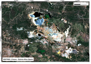
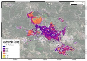
- To test the integration of multispectral (Sentinel2 and ASTER), SAR (Sentinel1) and DEM-based geomorphic analyses for mineral exploration
- To create new and adapted concepts for a combined use of satellite- and drone-based multi-sensor observations and ground monitoring methods
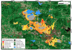
- To test the suitability of different Machine Learning algorithms in order to define classification schemes adapted to mineral exploration
- To create approaches that have high-performance in terms of environmental impact and cost
For more information contact info@rawmatcop.training